


")


Dozens of people have had to leave their homes in Whanganui and Rangitikei, and hundreds more are on standby, with widespread flooding expected. Follow RNZ’s live coverage here.
The two central North Island councils declared local states of emergency on Tuesday evening as the remnants of deadly Cyclone Debbie hit New Zealand.
Heavy rain warnings are in place for much of the central North Island, including Gisborne, Coromandel, Hawke’s Bay and Taranaki, as well as Auckland and Wairarapa.
Two large landslips triggered evacuations in Auckland.
Are you being affected by the wet weather? If it’s safe for you to do so, you can email photos and video to RNZ at[email protected]. Please include your contact details if you are willing to speak to one of our reporters.
Read a summary of what you need to know and follow RNZ’s live coverage here:

The occupants of a car sinking in flood water in the Waikato have escaped without injuries.
The car is on State Highway 23 in Whatawhata, east of Hamilton.
The ambulance service and fire crews are at the scene.
Horizons Regional Council has delayed its planned evacuation of people living alongside the river in Whanganui.
It had been planning to do this from 6am.
But staff at the council say less rain fell than was expected over the past few hours.
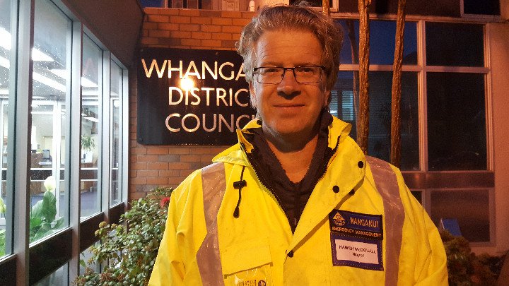
The mayor Hamish McDouall says the issue will be reconsidered at 10 am.
Meanwhile staff have deployed flood defences barriers on several parts of Whanganui and nearby Whangaehu and Turakina remain on high alert.
Staff also activated the flood control gates at Moutoa on the Manawatu River.
Just in from emergency services:
Crews are responding to a car sinking in flood water with occupants inside in the Waikato.
The car is on State Highway 23 in Whatawhata, east of Hamilton.
The ambulance service and fire crews are at the scene.
Horizons Regional Council says it activated floodgates at Moutoa at 2.15 this morning.
Staff there also deployed flood defences barriers at Whanganui Yacht Club and two other places in the area, Kowhai Park and Balgownie.
Nearby Whangaehu and Turakina also remain on high alert.
Horizons controller Craig Grant says while less rain fell than was expected over the past few hours, this still remains a significant event.
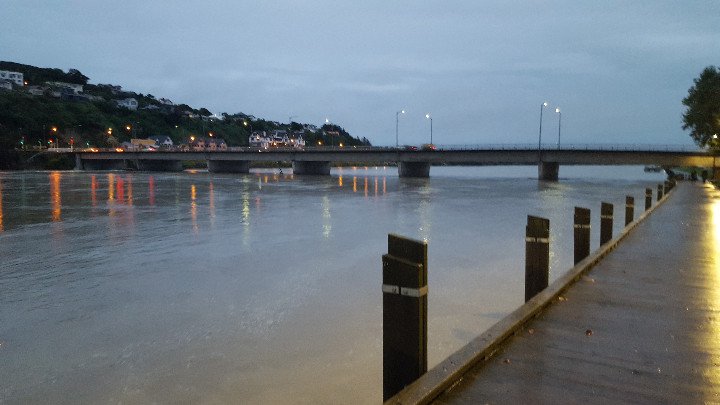
Staff now expect the Whanganui River to peak at Pipiriki at 13.8 metres above the floor of the river around 11pm today.
This will result in a peak of 8.5 metre peak in Whanganui at 6.45am Thursday morning.
Whanganui District Council declared a state of emergency yesterday.
They were earlier planning to evacuate people from 6am, however further assessment of expected weather and river level modelling may delay this urgency.
The two Civil Defence Welfare Centres at Whanganui Girls’ College and St Paul’s Church will be open from 6am, and schools in the district are closed today.
The Whanganui River this morning.
The fire service had more than 200 weather related call-outs for the northern region overnight – mostly relating to flooded houses in in Auckland.
Fire Service northern communications shift manager Daniel Nicholson said there had been 145 calls in Auckland, 18 in Waikato and 5 in Northland since 5.30pm yesterday – and about 170 were related to flooded houses.
The weather is easing in northern areas but there are still road closures in Auckland that will affect commuters. Great North Road and Clark St in New Lynn are closed.
In Waikato, a slip closed SH 25 between Whalebone Bridge and Ruamahunga, SH3 at Awakino Gorge is closed and State Highway 56 at Opiki is also closed due to flooding.
The regional council for Whanganui and Rangitikei has just given this updated forecast of river level rises.
“We now expect Whanganui River to peak at Pipiriki at 13.8m around 11pm – this will result in an 8.5m peak at Town Bridge at 6.45am Thursday.
Last night the council had predicted the river would rise to 19.3 metres at Pipiriki by 1pm.
“While this still remains a significant event, it is now predicted to be on a smaller scale than that of the 2015 flood event,” Horizons controller Craig Grant said.
The council activated the Moutoa floodgates at 2.15am and deployed flood defences barriers at Whanganui Yacht Club, Kowhai Park and Balgownie due to high water levels in the Whanganui and Manawatu Rivers. Whangaehu and Turakina also remain on high alert.
Whanganui District Council was planning to evacuate people who live nearest the river at 6am, but the latest assessment might may delay this urgency, the council said.
Two Civil Defence Welfare Centres at Whanganui Girls’ College and St Paul’s Church will be open from 6am, and schools in the district are closed today.
Rangitikei District Council has also declared a state of emergency and advised residents of evacuations in the Marton area overnight.
“Whangaehu and Turakina property owners were contacted about the flooding of farmland, originally expected to occur this afternoon. This timeframe has now been changed to later this evening with Whangaehu expected to peak at 10m at 7.30am tomorrow morning,” Mr Grant said.
Emergency Coordination Centre staff will continue to monitor as SH3 may potentially close tomorrow at approximately 10am.
The Makino is expected to peak 1.9m at 12noon today, and again 2.4m at 12.30am Thursday. Farmers who use the Makino spillway will be updated as gate operations are likely.
A mudslide triggered by the heavy rain crashed down a bank into an apartment block in the Auckland suburb of Kohimarama last night, forcing people to flee their homes.
Fifteen residents of the San Remo apartments in Kohimarama Rd were evacuated, and six from neighbouring properties.
Police officers have remained at the scene overnight and the street remains cordoned off.
-RNZ


