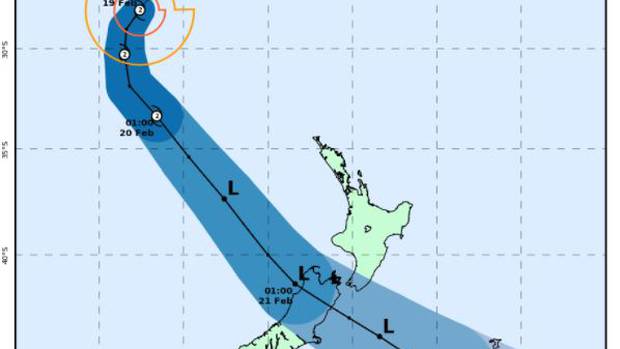
Updated: 7:55am – The “calm before the storm” is covering New Zealand as Tropical Cyclone Gita edges closer bringing wind gusts of over 120km/h, heavy rain and 8 to 9 metre swells.
Metservice meteorologist Nick Zachar said this morning’s tracking update showed the brunt of the storm approaching from the top of the South Island, from Westport through to Farewell Spit.
The category 2 cyclone, which ravaged Tonga and parts of Samoa, southern Fiji and New Caledonia, is now in the Tasman Sea.
Gita is expected to re-curve towards the southeast today and track towards New Zealand while transforming into an ex-tropical cyclone.
“It has turned southeast now, and the weather models are quite on agreement it will come through coastal Buller and Nelson, and head east and southeast towards Cook Strait and continue pretty rapidly from there, from Tuesday and early Wednesday.
“Unfortunately some of the areas hit by Fehi will see significant rainfall this time as well.”
Mayors and council chairs in the West Coast region met on Sunday to discuss storm preparations, and would meet later again today to discuss the latest predictions.
As the ex-cyclone approaches New Zealand it will combine with several systems already above the country, bringing heavy rain from South Taranaki through Wellington, Nelson and down to Buller through to tomorrow morning.
Rainfall of more than 100mm will be common, bringing significant flooding in the ranges, Zachar said.
-NZH
Featured image: How Tropical Cyclone Gita is tracking over the next few days. Image / New Zealand Metservice


